Indicator
Share of New Development Occurring in Highly and Partially Infill Supportive Areas
This indicator uses the Northeastern Illinois Development Database (NDD) to measure the cumulative share of development that occurs in the region’s highly and partially infill supportive areas. This measure addresses a critical element of ON TO 2050: encouraging development in existing communities where infrastructure to support it is already in place while also avoiding the expansion of new infrastructure with long-term maintenance costs. Developments that are completed or under construction will be tracked. For this indicator, the term “development” is used in a general sense to include both new development and redevelopment of existing uses. Residential and non-residential development will be tracked separately.
Targets
Due to the disparate nature of residential and non-residential development, separate target values and units of measurement will be used to track the progress of each development type. Reporting residential development in terms of units and non-residential development in terms of square footage is the industry standard; there is no simple method to develop an equivalency between the two. Targets are based on recent trends in residential and non-residential development and consider forecasted growth in housing units and jobs in the Chicago region.
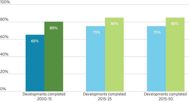
Sixty-five percent of residential developments and 80 percent of non-residential developments completed in 2000 through 2015 occurred within highly and partially infill supportive areas. Since 2016, 85 percent of residential developments and 89 percent of non-residential developments that have been either been completed or approved and are expected to be completed by 2025 are within highly and partially infill supportive areas.
The 2025 and 2050 residential and non-residential targets reflect a near-term share of development in highly and partially infill supportive areas that is halfway between the 2000-15 rate and the currently observed 2016-25 rate, and sustaining that trend in the long term by promoting strategies supportive of infill development. All targets reflect forecasted infill development and assume implementation of ON TO 2050’s infill-related strategies.
Residential Development
2025: 75 percent or more of new residential units developed since 2015 located within highly and partially infill supportive areas
2050: 75 percent or more of new residential units developed since 2015 located within highly and partially infill supportive areas
Non-Residential Development
2025: 85 percent or more of non-residential square footage developed since 2015 located within highly and partially infill supportive areas
2050: 85 percent or more of non-residential square footage developed since 2015 located within highly and partially infill supportive areas
Sections
- Actual (residential)
- Actual (non-residential)
- Target (residential)
- Target (non-residential)

Inclusive Growth Perspective
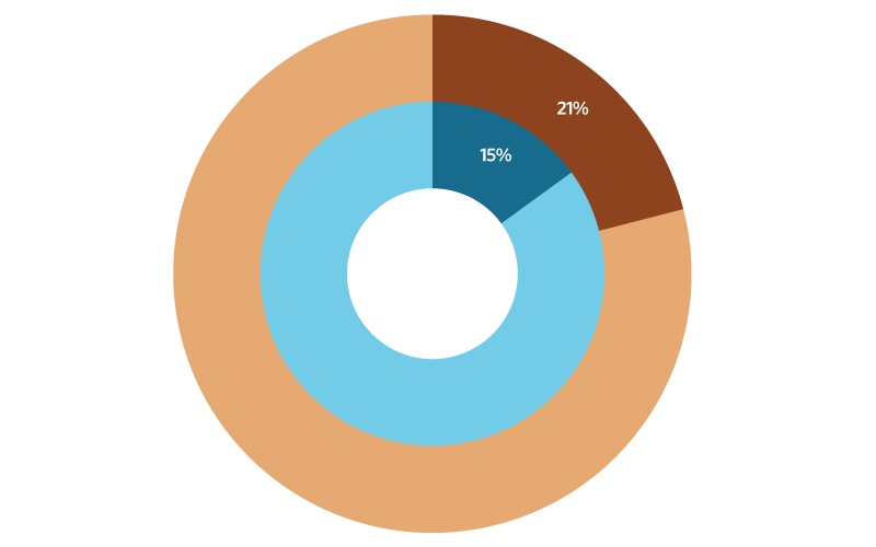
Infill development and land use patterns are crucial to promoting economic growth in many economically disconnected and disinvested areas and in connecting the region’s economically disconnected and disinvested area residents to economic opportunity. As a kindred indicator to this core indicator, ON TO 2050 will track the share of new infill development occurring in economically disconnected and disinvested areas. Roughly forty percent of the region’s population lives in economically disconnected or disinvested areas. However, economically disconnected and disinvested areas accounted for only 15 percent of new infill residential units and 21 percent of new infill non-residential square footage between 2000 and 2015. CMAP recommends increased infill development in economically disconnected and disinvested areas to increase efficient use of limited resources and help these communities grow.
- Disinvested and Economically Disconnected Areas (residential)
- Rest of the region (residential)
- Disinvested and Economically Disconnected Areas (non-residential)
- Rest of the region (non-residential)

GO TO 2040 Context
This indicator was based on the “Share of New Development Occurring within the Existing Municipal Envelope” indicator from the GO TO 2040 Plan Update. While the change in the area of interest from the municipal envelope to highly and partially infill supportive areas makes comparisons between the two difficult, it should be noted that progress towards the GO TO 2040 targets has been impressive. From 2008-2015, 94.9 percent of residential development and 96.4 percent of non-residential development occurred within the municipal envelope. The 2040 targets were 60 percent and 75 percent, respectively.