Land Consumption Scenario Outcome
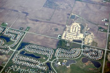
"Land consumption" refers to the conversion of open space or farmland to residential, commercial, office, or other developed land uses. As the region grows and expands, some consumption of these areas is inevitable. However, conserving open space and farmland does create economic, environmental, and social benefits, and reducing the rate of consumption of these areas is desirable.
Farmland
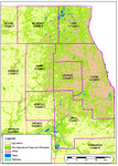
The region currently has around 850,000 acres of farmland, or one-third of the region's total area. This is by far the single largest land use in the region. Click on the thumbnail map to see the parts of the region currently used for agriculture. For the last several decades, the region has lost around 15,000 to 20,000 acres of farmland per year. If these trends continue, nearly 500,000 acres (55%) of the region's farmland will be consumed between now and 2040.
The impacts of each scenario on farmland consumption are described below, estimating the number of acres of farmland that will be consumed compared to the current trend (with a decrease considered to be an improvement). The base figure is 490,000 acres.
These estimates were calculated by comparing the amount of agricultural land to forecasts for each scenario. A summary of the difference between scenario forecasts which breaks the region into "density districts" is available here.
How would this scenario change from the reference? |
|
|
Reinvest |
Improves greatly |
|
Preserve |
Improves |
|
Innovate |
Improves slightly |
Change in consumption of farmland |
|
|
Reinvest |
-28% (138,000 fewer acres) |
|
Preserve |
-13% (65,000 fewer acres) |
|
Innovate |
-4% (20,000 fewer acres) |
What strategies in this scenario caused this change? |
|
|
Reinvest |
An aggressive farmland preservation program was employed, and development was concentrated in more densely developed areas |
|
Preserve |
A moderate farmland preservationprogram was employed, and more development occurred in moderately dense areas. |
|
Innovate |
Some developments included farmland protection as part of conservation design principles. |
Open space
The region currently has around 310,000 acres of protected open space (forest preserves, conservation districts, parks, and similar areas). The Green Infrastructure Vision highlights areas where additional open space acquisition and application of environmental design features should occur. The area within the GIV contains an additional 410,000 acres of open space and farmland which are critical natural areas but are not currently protected. If current trends continue, approximately 190,000 acres of unprotected open space within the GIV are forecast to be lost, or nearly half of the region's total.
The impacts of each scenario on open space consumption are described below, estimating the number of acres of open space that will be consumed compared to the current trend (with a decrease considered to be an improvement). The base figure is 190,000 acres.
How would this scenario change from the reference? |
|
|
Reinvest |
Improves |
|
Preserve |
Improves greatly |
|
Innovate |
Improves |
Change in consumption of open space |
|
|
Reinvest |
-37% (71,000 fewer acres) |
|
Preserve |
-65% (124,000 fewer acres) |
|
Innovate |
-36% (68,000 fewer acres) |
What strategies in this scenario caused this change? |
|
|
Reinvest |
Development was concentrated in more densely developed areas, reducing pressure on open space. |
|
Preserve |
More development occurred in moderately dense areas. Also, a substantial open space acquisition program was pursued to preserve the most sensitive open space areas in the region. |
|
Innovate |
Most new developments preserved open space as part of conservation design principles. |
These estimates were calculated by comparing the amount of farmland and open space to forecasts for each scenario. A summary of the difference between scenario forecasts which breaks the region into "density districts" is available here.