This page contains data collected from the 2000 Census release, and should be used for archival purposes only.
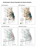
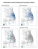
Regional maps of Population Density and Employment Density changes 1970- 2000. (See below.)
|
Map of Population Density & Change, 1970 -2000 (PDF)
|
Map of Employment Density and Change, 1970-2000 (PDF)
|
For statistical tables and maps of northeastern Illinois counties, townships, and municipalities, please click any of the links below.