Wheeling
Wheeling Transportation Plan
Update: This project was completed in January 2013.
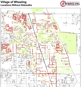
In 2011, the Village of Wheeling requested assistance to produce a multi-modal transportation plan. Through this effort, the Village sought to establish better connections with neighboring jurisdictions, enhance use of existing and planned recreational facilities, strengthen the local economy, and provide healthy, environmentally-friendly transportation options for its residents and visitors. The plan will develop a comprehensive active transportation network including on and off-street accommodations for bicyclists, pedestrians and transit riders. The plan will also include necessary program and policy improvements to encourage more use of the network. The Village wishes to better integrate land use and the active transportation network while fostering transit oriented development. The Village also seeks additional economic benefits that can result from increased patronage of local businesses. This will be accomplished by creating better local connections for bicycling, walking and transit.
Implementation Updates
CMAP, in partnership with the Wheeling Park District, created the Wheeling Park District Bike Map, which highlights safe trails to all Wheeling Park District locations and regional bikeways. Producing and distributing this free active transportation network map was a recommended action of the Wheeling Active Transportation Plan, and will help create awareness for walking and biking routes in the Village and encourage the use of active transportation. Routes include the Prospect Heights Bike Path, Northgate Parkway, and Dundee Road, which connects to the Des Plaines River Trail, a 56-mile path that follows the Des Plaines River.
Contact
Lindsay Bayley, CMAP Senior Planner (lbayley@cmap.illinois.gov or 312-386-8826)