Northeastern Illinois is made up of a network of unique, identifiable communities, each with their own histories and characters. Each has its own "sense of place," and that diversity within the region is reflected in the way local governments plan for their development and future. When CMAP recently issued a call for projects for local technical assistance, the response was overwhelming -- over130 applications were received for more than 220 proposed projects. While eligible projects included zoning ordinance revisions and studies on important local issues, the single most common type of project proposed was an update or revision to a local comprehensive plan. So what do our region's existing local plans say? Over the past several years, CMAP staff spent considerable time answering that question.
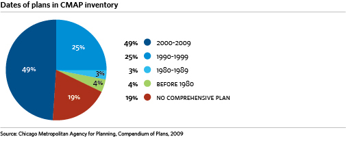
In September 2009, CMAP concluded an update to its inventory of comprehensive plans. Throughout 2008, staff contacted every municipality across the seven-county region, requesting the copies of their most recent comprehensive plans. At that time, 49 percent of our region's municipalities had completed a comprehensive plan since the year 2000, while 19 percent had no plan.
CMAP reviewed the 219 plans completed since 1980 for degree of emphasis on 66 different subject areas that align with the Illinois Local Planning Technical Assistance Act, as well as strategy areas of GO TO 2040. The Local Planning Technical Assistance Act states that local governments' land-use actions should be consistent with their comprehensive plans and calls for five core elements -- land use, natural resources, transportation, economic development, and housing -- to be included in all comprehensive plans. Compiling this compendium of plans allowed CMAP to understand which of the GO TO 2040 strategies were being implemented under current local plans. Each comprehensive plan is a product of its unique municipal context, and certain approaches to redevelopment or strategies to preserve land may be more appropriate in one sub-region than in others. If one community or sub-region places greater weight on any particular topic, it is not necessarily a reflection on the quality of the plans, or even their alignment with GO TO 2040 strategies. For example, attention paid to clusters of economic activity located in industrial parks or brownfield redevelopment may not apply to a bedroom community without a history of industrial uses.
As such, it was not surprising that Cook County municipalities focused more on housing preservation and transit-oriented development (TOD), while emphases on Tax Increment Financing (TIF), land preservation, and conservation design were more prevalent in the collar counties. However, a regional analysis shows some interesting results in the degree to which comprehensive plans emphasized specific GO TO 2040 strategies.
Land Use and Housing
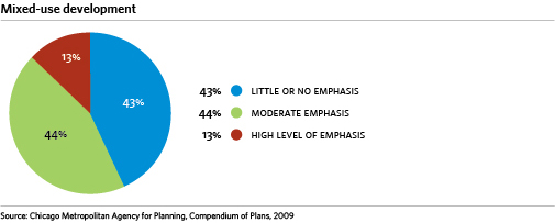
Many communities have used mixed-use development to restore the luster of their main streets and town centers, or in some cases to create new town centers. The Grayslake and Carpentersville plans are examples of good planning aimed at attracting mixed-use development to their town centers.
Concentration of activity around nodes, intersections, or corridors is also highly prominent in redevelopment approaches. Mixed-use development was moderately emphasized in 44 percent of the plans, and it was a central feature in redevelopment efforts for 13 percent of the plans surveyed.
Redeveloping infill sites can also offer substantial benefits, such as revitalizing stressed communities, increasing tax revenues, providing opportunities to create affordable housing, preserving natural resources in undeveloped areas, and effectively using existing infrastructure and services. As defined in the GO TO 2040 Infill Snapshot Report, potential infill parcels lie within current municipal boundaries, have an area greater than 2,000 square feet, and cannot be designated as open space or agriculture. Of plans surveyed, nearly half (46 percent) placed moderate emphasis on infill redevelopment.

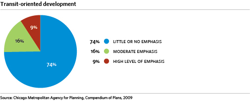
TOD is a concept that received little or no emphasis in 74 percent of plans. However, 17 percent had a moderate emphasis on TOD, and the concept played a prominent role in economic development strategies for nine percent of plans. It should be noted that a number of communities -- especially in the south suburbs -- did not include TOD in their comprehensive plans but have completed "Station Area" plans with help from the Regional Transportation Authority (RTA). For example, the Village of Hazel Crest worked with Teska Associates to develop a station area plan. In some cases, these plans result from interjurisdictional collaboration, as was the case when Park Forest, Matteson, and Olympia Fields worked together on the 211th Street Metra Station TOD Study.
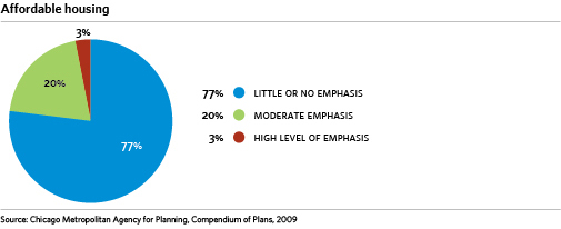
While often controversial, the issue of affordable housing has become more prominent in the wake of the recession and foreclosure crisis. Of plans surveyed, 77 percent did not include provisions for affordable housing, compared with 92 percent that had little or no emphasis on the topic in 2004 when the now-defunct Northeastern Illinois Planning Commission conducted a similar survey. This increase in emphasis may correspond to the Affordable Housing Planning and Appeal Act passed in 2003 by Illinois, as many of the plans that feature this topic reference that law. Very few plans prioritized the issue or gave any detail to the municipality's role in the further provision of affordable housing.
Parks and Open Space
Public parks are included in virtually all comprehensive plans. Many communities expressed concern about maintaining the present capacity of their parks, and many others identified opportunities for expanding green space. The majority of plans (58 percent) addressed land and park preservation with some detail. Significantly, only 16 percent of the plans gave the subject little or no emphasis.

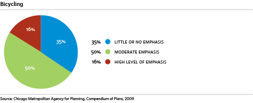
Bicycling
Bicycling is addressed in many plans within the region. The City of Batavia adopted a bicycle plan in 2007 as part of its comprehensive plan. The City of Oak Forest's 2008 comprehensive plan also includes a Pedestrian and Bicycle Mobility Plan. Oak Forest went on to commission an in-depth Non-Motorized Plan with the help of the Active Transportation Alliance and Baxter Woodman. Bicycling was mentioned with a moderate level of emphasis in half of the plans surveyed by CMAP. Notably, 15 percent placed heavy emphasis on this form of transportation. Many of these plans developed a small bicycle plan component to their comprehensive plan and provide examples for other communities to follow.
Workforce Development
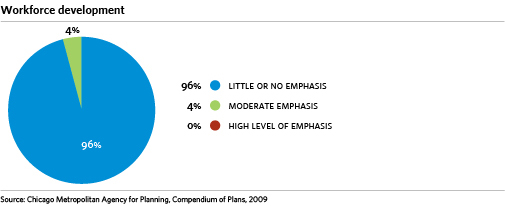
An educated and employed populace is essential to the future prosperity, quality of life, and economic competitiveness of our region. Businesses of all types consistently rate the quality and availability of a diverse and talented workforce as one of the most important factors influencing their location decisions and ability to succeed. Because comprehensive plans tend to focus on infrastructure and facilities, they rarely address workforce issues. Very little emphasis was placed on "workforce development," as only 4 percent of plans surveyed had moderate emphasis, with the rest (96 percent) giving the subject little or no emphasis. By focusing on workforce development strategies, communities would be able to help residents in need while at the same time strengthening the vitality of the local economy and providing greater stability in their neighborhoods.
Conclusion
As detailed above, CMAP analysis shows that GO TO 2040 strategies are addressed by municipal comprehensive plans to varying degrees. Some of that variation is explained by how land use patterns, access to transportation facilities, density, and policies differ locally across the region. However, much of it may be due to a lack of municipal capacity to update their plans at all, much less address topics not traditionally covered by comprehensive plans.
CMAP seeks to help fill these gaps through the agency's new local technical assistance program sponsored by the U.S. Department of Housing and Urban Development (HUD) as part of the federal interagency Partnership for Sustainable Communities. Among the first wave of local communities identified for planning assistance, two examples include the first-ever comprehensive plan for the City of Blue Island and a land use and infrastructure plan for the Fairmont area, a community in unincorporated Will County. CMAP has begun working with 64 local governments, nonprofits, and intergovernmental organizations to address local issues at the intersection of transportation, land use, and housing, including the natural environment, economic growth, and community development.
Note: In the spring and summer of 2010, CMAP conducted a survey of municipalities across the region that may update some of the information contained in this blog entry. Check back for analysis of that data later this spring.