The first installment of this series introduced the Central Lake County Corridor and illustrated the concept of "modern boulevards" by surveying historic parkways. This second installment reviews contemporary examples of context-sensitive parkway-type facilities in the U.S. These facilities serve more uses than recreational motoring, and in some cases showcase the reconstruction and redevelopment of existing transportation facilities. Newer projects utilize the boulevard concept in order to support multimodal travel, improve safety, and promote strong aesthetics.
Paris Pike, Kentucky
Opened: 2003
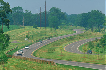
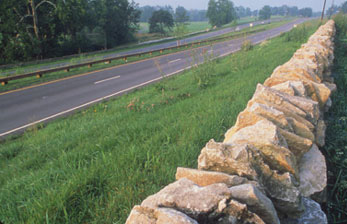
The Paris Pike is a 13-mile, four-lane facility in the heart of Kentucky's Bluegrass Country northeast of Lexington. In response to safety concerns and growing traffic congestion, in the 1960s the Kentucky Transportation Cabinet announced plans to upgrade what was then a two-lane facility to create a four-lane divided highway with wide median. Local community groups opposed this proposal and won an injunction against the widening project moving forward. In the 1990s, an interdisciplinary Advisory Task Force developed a new, more context-sensitive design, and the Paris Pike project was completed in the early 2000s.
The context-sensitive design conserved environmental and cultural resources and promoted strong aesthetics. These measures include:
- Soil: Silt loam topsoil was removed during construction, saved, and replaced at original thickness after the project was completed. The landscaping included local plant species.
- Materials: The project incorporated steel-backed timber guardrails, grass shoulders, and both stone fences and stone-faced bridges that match local stone outcrops.
- Alignment: Roadway and utility alignments were adjusted to avoid historic properties. Additionally, traditional cut-and-cover techniques were minimized to better fit the natural contours of the land.
Source: Context Sensitive Solutions.org, FHWA
Source: FHWA

Source: FHWA
US-285, Colorado
Opened: Construction ongoing, received final federal approvals in 2007
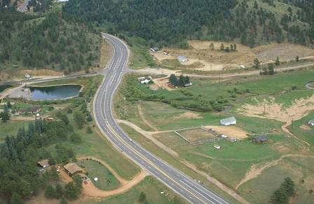
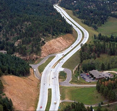
This project is currently upgrading 14.7 miles of highway from two to four lanes in response to congestion and safety concerns. US-285 extends southwest of Denver through scenic, mountainous terrain. It lies in the South Platte River watershed, passing historic properties and through various wildlife habitats.
In this context, the project faced key land use and environmental issues during the development process. Working with a wide array of stakeholders, the Colorado Department of Transportation developed a project that earned strong community support and identified project cost savings through value engineering. The final project includes grade-separated interchanges that fit into the mountainous context by staggering and shortening access ramps. The design avoids wetlands takings, incorporates wildlife crossings, and carefully limits access points to reduce the potential for sprawl development. Aesthetic detailing such as textured bridges and rock cuts mimic the natural setting.
The project will soon be completed—the current Colorado FY 2012-2017 State Transportation Improvement Program includes an additional $1,066,000 in FY 2012 for the project, but no further funding from FY2013 onward.
Source: Context Sensitive Solutions.org, FHWA
Source: Gaskill, Craig, 2007, Cost-Benefit Study of Applying Context Sensitive Solutions to US 285, West of Denver, Colorado. Transportation Research Board Annual Meeting, 2007. Paper #07-0098.
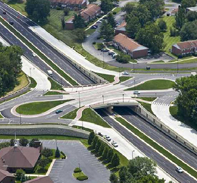
Keystone Parkway, Indiana
Opened: 2010
In the mid-2000s, Indiana Department of Transportation proposed adding a third lane and turning lanes along Keystone Avenue in Carmel, a northern suburb of Indianapolis. The City of Carmel offered a counterproposal to grade-separate Keystone Avenue at six major intersections and to develop "tear-drop" roundabout interchanges at these crossings. Roundabouts have the potential to reduce crashes, increase vehicle throughput, and reduce fuel consumption and emissions. After implementation of this alternative, Keystone Avenue is free-flowing within Carmel city limits, reducing congestion, and improving pedestrian crossings. The total project cost approximately $110 million.
Source: Carmel Link, 126th Street Intersection, Completed Intersection Overview Photo

Source: Carmel Link

Source: Carmel Link, 106th Street Intersection, Completed Intersection Underpass Photo