NOTE: This is the second in a three-part Policy Updates series on GO TO 2040 Major Capital Projects:
Keeping Tabs on the Major Capital Projects in GO TO 2040
Major Capital Project Series -- Central Lake County Corridor
When regional plans like GO TO 2040 are produced, one relatively small component typically attracts the most attention -- the identification of new major transportation projects. For projects to receive federal transportation funds or obtain federal approvals, they must be included in these plans. As the name implies, "major capital projects" add capacity, come with large price tags, and often promise to generate economic returns, reduce congestion, improve mobility, and, sometimes, even transform large parts of our region. GO TO 2040 includes five new major projects or extensions, all of which have been moving forward in terms of their own individual planning processes.
Over the next several weeks, CMAP's Policy Updates blog will provide updates on how these projects are developing. The first piece examined the Elgin O'Hare Expressway and West O'Hare Bypass Improvements. This piece will focus on the Central Lake County Corridor (CLCC) project.

Designing the Central Lake County Corridor
The CLCC project consists of two main elements:
- A suite of improvements to Illinois Route 120, including widening the road and constructing a bypass at Grayslake.
- The extension of Illinois Route 53 north from where it now ends at Lake Cook Road to join Route 120.
Evaluation of the project for GO TO 2040 indicated that, of all the 52 major highway and transit projects examined, it would have by far the highest congestion reduction benefits. All the add-lanes projects on I-80, I-55, I-290, and I-94, while critical, still would not achieve the congestion reduction that the CLCC would. Congestion is a significant drag on regional productivity, and addressing it pays substantial benefits to businesses and residents. Moreover, the benefits of congestion reduction as a result of this project extend widely through the region.
Economic analysis suggests that the project would also contribute $0.5 billion to income in the region over a relatively short term -- more than twice what any other project would achieve -- with similar effects on job creation. Given the benefits, it is one of only two new highway projects recommended as priorities in GO TO 2040. Still, there are important decisions to be made about the design of the facility, and this update focuses on the design issues. Like the Elgin O'Hare West Bypass project, financing the CLCC will also be a significant challenge.
Route 120
The Lake County Division of Transportation (LCDOT) has taken the lead on the Route 120 portion of the project. Acting with the Route 120 Corridor Planning Council, a project committee composed mostly of local governments in the area, the LCDOT conducted a corridor study to define alternative improvements for the road. Wrapping up in late 2009, the study established a locally preferred alternative for the roadway, as well as planned land use along the corridor. The preferred alternative is a four-lane boulevard design with space for bike lanes and stormwater treatment in the right-of-way. This is more appropriate to the character of central Lake County than a larger scale, limited access six-lane roadway. A number of design issues broached by stakeholders were not completely resolved, such as whether roundabouts could be used at intersections given the high traffic volumes. Roundabouts would limit the amount of land that has to be devoted to interchanges and would probably improve the "fit" of the roadway with its surroundings, but their safety has not yet been fully analyzed.
Proceeding further with the project will require conducting additional studies, starting with "Phase I engineering," presumably led by the Illinois Department of Transportation. However, funding for Phase I engineering for Route 120 was not included in IDOT's 2012–2017 Transportation Improvement Program, making funding for this and other phases of the project uncertain.
Route 53
The Route 53 portion of the project is in a different phase of progress -- it has not been studied closely in a decade. The Lake County Transportation Improvement Project (LCTIP), completed in 2001, included the Route 53 north extension as one of the alternatives. However, the Route 53 north extension never advanced into detailed study because of concerns over the character of the roadway, impacts to natural resources, perceived lack of consensus on its construction and lack of a funding plan. The Illinois Tollway is now considering whether to include Route 53 a priority as it looks to develop its ten-year capital program over the next several months.
Because of the lack of major north-south thoroughfares in central Lake County, there is pent-up demand for north-south travel. Moreover, significant mobility benefits can be achieved even with a boulevard or parkway design like the Route 120 portion, perhaps with a speed lower than is typical on a road designed to expressway standards. That would allow for less sweeping roadway geometry and could permit alternative interchange designs, both of which would use less land and fit better with community character.
Environmental Challenges
Still, environmental issues remain, and they will have to be addressed during engineering studies. One major issue is impacts to wetlands, which were estimated at 92 acres in the LCTIP study. Some of the wetlands in the corridor are high quality. It may be that some of the wetlands can be avoided with a narrower roadway or tighter turns, or simply more careful construction practices, but compensatory mitigation will still be needed. With mitigation ratios in the 1.5:1 to 5.5:1 range, a rather large investment in wetland protection and restoration may be on tap, especially if avoidance is difficult and mitigation ratios are high. For comparison, the O'Hare Modernization Program, which had the largest mitigation requirements in recent memory, impacted 154 acres of wetland and led to 447 acres of required compensatory mitigation.
It is critical to make sure that compensatory mitigation for wetland impacts is done in such a way as to get maximum benefit -- replacing the right types of wetlands and wetland functions and in the right locations. Therefore, a major part of project planning should be to undertake a study, at the direction of the permitting authorities and other stakeholders, to make sure that mitigation is able to help achieve ecological priorities. A number of federal agencies have been looking into the idea of an "ecosystem-based approach" to designing large infrastructure projects such as highways, which could be of assistance in designing Route 53.
Besides wetland impacts, the following would likely occur:
- Portions of parks and forest preserves would be taken (about 20 acres in total), generally along the edges.
- Pollutant runoff would increase -- salt, metals, and oil compounds in particular.
- Several new stream crossings would be needed.
- The habitats of threatened/endangered species could be affected, although the extent and severity are not very clear.
These impacts (not an exhaustive list) are generally more minor than the impacts to wetlands, but they still need to be mitigated, and techniques exist to do so. As an example, pollutant runoff could be mitigated with a commitment to the use of best management practices (BMPs) in handling runoff. This would probably include drainage into swales, use of wetland detention, and devices to infiltrate the runoff from smaller storm events arranged in a "treatment train" to maximize the removal of pollutants. The agency with responsibility for operations would need to make arrangements for greener forms of de-icing, such as use of alternatives to sodium chloride or more controlled application since BMPs are generally ineffective against chloride.
Potential New Development
Aside from these direct impacts, perhaps the biggest question about the Route 53 north extension is whether it would lead to more development, indirectly causing environmental damage. Opponents of the project have often said that this is the case, and have sometimes suggested that stimulating growth is the true purpose of the project. From the standpoint of GO TO 2040, however, the purpose of the road is to decrease current congestion and travel times. Furthermore, the LCTIP study suggested that forecasted population in Lake County as whole would not be appreciably different with the road in place.
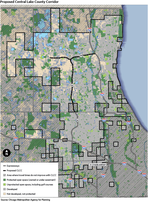
The more relevant question, perhaps, has to do with specific areas that might be made more "developable." The map above shows areas that would experience a decrease in travel times with the CLCC, making those areas incrementally more attractive places to live or work. Thus, having the CLCC in place will probably increase the development potential of the land in west-central Lake County somewhat, as well as perhaps parts of eastern McHenry County. Although the land surrounding the Route 53 extension alignment is mostly developed, there is a large agricultural area just southwest of the proposed interchange with Route 120. Except for industrial use near the road, the Lake County Framework Plan has this area as mostly agricultural, and local municipal comprehensive plans generally see it as rural buffer area. But the value of this land would be increased, and plans do change. Thus, a critical part of future study on the Route 53 extension should be to prepare a strategy for the areas around the road that utilizes the principles of livability. In this case, that would mean establishing legal protection for the most important resources in the area while developing compactly on the sites suitable for it to ensure that new communities are designed for walking and biking.
Conclusion
The CLCC is recommended in GO TO 2040 because it will have a clear and positive regional benefit -- in fact, a higher benefit on most measures than any other surface transportation project that has been proposed anywhere else in the region. Furthermore, a strong case can be made that negative local impacts can be avoided or mitigated through design if stakeholders accept that the project is worth doing and if impacts are tackled early in project planning. The roadway can be designed so that it is pleasant to drive and not unpleasant to live near. Essentially, the question is whether stakeholders in the region can collaborate to build it. Finally, a number of agencies have been involved in planning for CLCC, but there is now a leadership void; it will be necessary for an agency to sponsor further planning.