Bus Rapid Transit (BRT) has garnered growing recognition as a flexible, cost-effective solution for addressing transit needs and providing a commute alternative in congested areas. Today the region faces significant mobility challenges as evidenced by increasing congestion, cuts to public transit, and deferred maintenance of critical transportation infrastructure. To address this, CMAP's GO TO 2040 plan identifies a set of priority transportation projects for the region, with a focus on moving the existing system toward a state of good repair. Bus-based solutions like BRT are one option to provide transit on the proposed new and upgraded expressway facilities in the region and are being evaluated or tested for several of the major capital projects outlined in GO TO 2040.
As major capital projects and BRT initiatives in the region move forward, it is critical to plan for land use that will support these transit investments over the long term. CMAP recently published Land Use Policies and Strategies for Expressway-Based Bus Rapid Transit as a policy and strategy guide as well as a technical document, both of which focus on ways to encourage supportive land use for expressway-based BRT. The documents not only outline strategies to promote supportive land use, but also emphasize the need to site stations and transit infrastructure in a way that best lays the groundwork for supportive land use to occur, identify key pedestrian and bicycle access strategies, and recommend ways to address negative perceptions of BRT and bus-based transit systems.
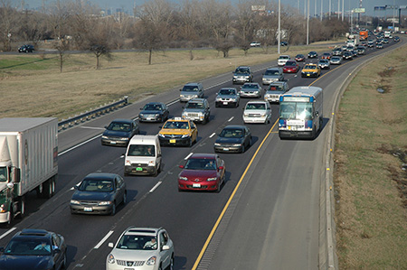
Pace initiated the two-year, I-55 Bus on Shoulder demonstration project in November of 2011. The initiative has proved successful, and additional service was added in March 2012. Source: Pace
Region-wide, nearly 50 percent of all jobs (including those in downtown Chicago) are located within one mile of an expressway entrance or exit. GO TO 2040 emphasizes the need to provide improved jobs-housing connections as a way to reduce congestion and commute times, and providing enhanced transit like BRT on our expressways offers the opportunity to improve access to the region's employment centers. While the distances involved and the less-concentrated nature of development in expressway corridors present a significant challenge to providing transit services, improved transit in these areas could provide more reverse commute and suburb-to-suburb commute options. However, creating supportive land use patterns is critical to the long-term success of these expressway-based transit lines. A recent literature review by the Center for Transit-Oriented Development (CTOD) indicated that transit lines with higher employment counts near transit stations have higher ridership and that employment centers with both larger total employment counts and higher employment concentrations generate the highest ridership levels. Institution of land use policies that encourage employment and housing clusters near BRT transit stations and promote integration of transit into development can facilitate a transition toward transit-supportive development patterns in expressway employment corridors.
The expressway environment presents significant land use and design challenges: the physical divide created by an expressway makes pedestrian access to stations difficult; new development often turns away from the noise and traffic of the expressway, limiting access to expressway-based stations; employment centers are rarely a walkable distance from highway interchanges; and the overall densities on these corridors are often lower than that required to support walkability and transit. To address these issues and promote supportive land use, the Policy and Strategy Guide offers recommendations in four areas:
- Station Siting: Station placement can provide a critical role in minimizing the negative externalities of the expressway and setting the stage for TOD. Recommendations in this section focus on providing alternatives to locating BRT stations within the expressway and/or at interchanges, highlighting opportunities to place stations within major commercial parks or adjacent to the expressway.
- Planning for and Implementing TOD: This section reviews traditional TOD strategies, with a particular emphasis on how they might be utilized to create TOD in a traditionally auto-oriented environment. These strategies focus on policy-level changes including addressing planning for transit corridors as a whole; creating and aligning station area plans, transit-supportive zoning regulations, and design guidelines; and providing regulatory incentives for transit-supportive development.
- Pedestrian and Bicycle Connectivity: Ensuring connectivity is a core tenet of TOD strategies and is an especially critical strategy for the expressway environment. This section emphasizes the need to create pedestrian connections not only to transit stations, but also within the TOD area, to surrounding developments and across the expressway.
- Marketing and Permanence: Overcoming negative perceptions of BRT and bus-based transit is critical to generate ridership and development interest. This section summarizes key takeaways from interviews with local developers and provides strategies to address the negative perceptions that BRT and bus systems face related to the quality of service, the permanence of bus systems, and the ability of bus stations to generate development interest.
To request printed copies of the guide or technical document, contact Hillary Green (hgreen@cmap.illinois.gov). Visit www.cmap.illinois.gov/brt to find PDFs of both documents.