Indicator
Percentage of Regional Greenways and Trails Plan Completed
This indicator tracks the total miles of all trails in the Northeastern Illinois Regional Greenways and Trails Plan (RGTP) that are completed or let for construction. The RGTP includes not only off-street trails, but key on-street facilities and side paths. The RGTP includes trails in Aux Sable Township in Grundy County. Out-of-region connections to systems in Indiana and Wisconsin are not included in indicator totals.
Targets
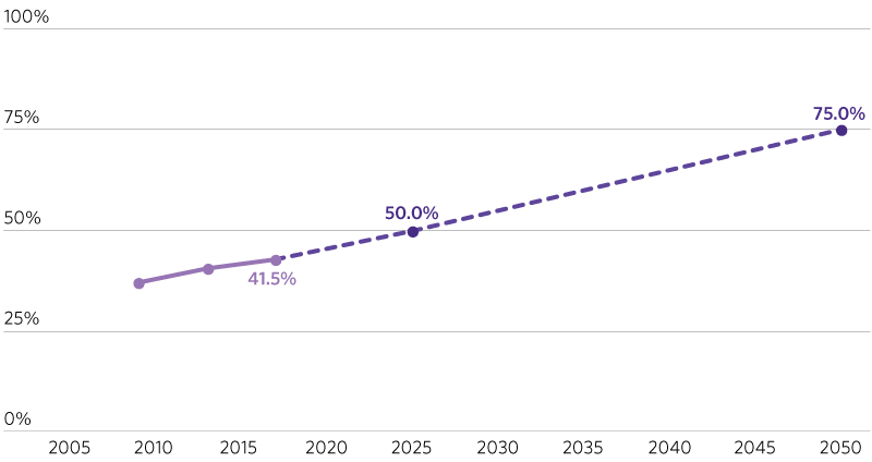
As of 2017, 41.5 percent of the 2016 RGTP has been completed, including both existing and programmed trail miles. Extrapolating the average annual rate of completion from 2009 to 2017 would yield 49 percent completion by 2025 and 68.1 percent completion by 2050. The proposed targets are slightly higher than those figures.
2025: 50 percent or more of RGTP completed
2050: 75 percent or more of RGTP completed
Sections
- Actual
- Target
GO TO 2040 Context
This indicator – a secondary kindred indicator in GO TO 2040 – has supplanted the less holistic “Trail Greenway Mileage” indicator, which was focused exclusively on the greenway components of the RGTP. This indicator also now uses the 2016 Regional Greenways and Trails Plan as its basis, whereas the GO TO 2040 indicator was based on the 2009 RGTP. As of 2015, the GO TO 2040 indicator measured 771 miles of greenways, below the 2015 target of 808 miles.